FP002 Quick Answer
R. L. Snyder, Biometeorology Specialist
Department of Land, Air and Water Resources
University of California
Davis, CA 95616, USA
Revised October 21, 2003
Predicting when the temperature falls to a critical value is important for starting active frost protection methods. In addition, the duration of temperature below the critical value is important for assessing potential damage. Starting at the proper temperature is important because it avoids losses resulting from starting too late and it saves energy by reducing the operation time of the various methods.
Assuming that the predicted minimum temperature (Tp) is correct and it will occur during the sunrise hour, then the nighttime hourly mean temperature trend from two hours after sunset through the sunrise hour is estimated using equations 1 and 2.![]() (1)
(1)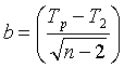 (2)
(2)
In Eq. 1, i =0 for the sunset hour and i=n for the sunrise hour the next morning. Ti is the mean air temperature for the ith hour and T2 is the mean temperature during the second hour following the sunset hour. Starting at hour i=2, which is two hours after the sunset hour, the mean hourly air temperature is predicted for each hour through the sunrise hour the next morning. The method is illustrated in Figure 1 (oF) and Figure 2 (oC). Note that the value for b depends on the temperature units. For oF, b=3.000 and for oC, b=1.773.
It is important to remember that this method will only work during radiation freezes with calm, clear nights when the temperature drops because of long wave radiation losses from the surface. Under windy and/or cloudy conditions, the temperature trend cannot be predicted using the approach presented here. However, radiation freezes do not occur during cloudy, windy conditions.
Generally, subtropical crops are most sensitive to freeze damage just before and during the harvest period when the temperature is lowest. The sensitivity of deciduous tree and vine crops to freezing temperature increases from first bloom to the small nut or fruit stages. Sensitivity is also higher when warm weather has preceded the frost night. Damage to a crop depends on how low the temperature goes and how long it is at the minimum temperature. Most published values for freeze damage to crops give the T10, T50, and T90 for 30 minutes at a given minimum air temperature. The T10, T50, and T90 are the air temperatures at which a 10%, 50% and 90% yield loss is expected when exposed to that temperature for 30 minutes. For example, given a T90=23oF=-5.0oC, we would expect more than 90% yield loss during the night of December 23, 1990 at the UC Lindcove Field Station.
At any given time during the night, the corresponding temperature is the predicted hourly mean temperature for the preceding hour. Therefore, the critical time for starting any active freeze protection method is one hour before the critical damage temperature is expected. For example, using the 8:00 p.m. temperature in Figures 1 and 2, the temperature between 7:00 and 8:00 p.m. is predicted to average 30.5oF (-0.83oC). If unacceptable freeze damage is expected for half-an-hour exposure to a temperature of 30oF (-1.1oC), then, to be safe, the freeze protection should start at about 7:00 p.m. rather than at 8:00 p.m.
Note that this prediction method is fairly accurate, but it is not perfect. The observed temperatures between 7:00-10:00 p.m. in Figures 1 and 2 are less than the predicted temperatures. Figures 3 and 4 show the predicted versus observed temperatures over several days. Clearly, sometimes the predicted temperature is higher and sometimes it is lower than the observed. Damage could result if you rely only on the temperature prediction, so the model should be used as a guide to tell approximately when the temperature will reach a critical value. However, air temperature should be monitored during the night to accurately determine the time for starting freeze protection.
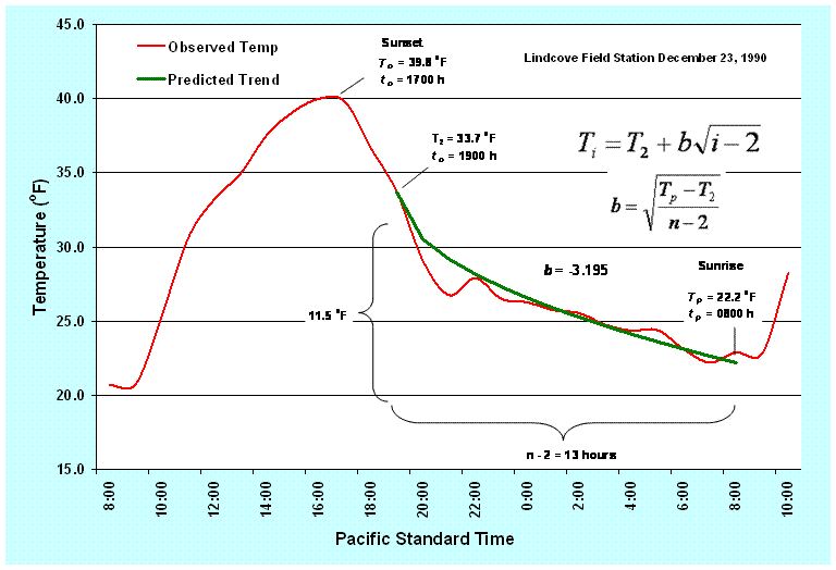
Figure 1. Observed and predicted hourly mean temperatures (oF) during a radiation freeze on December 23, 1990 at the University of California Lindcove Field Station.
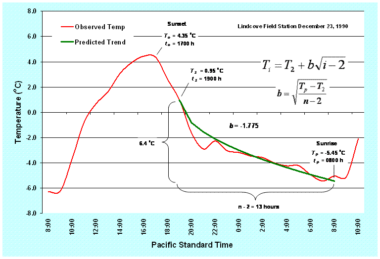
Figure 2. Observed and predicted hourly mean temperatures (oC) during a radiation freeze on December 23, 1990 at the University of California Lindcove Field Station.
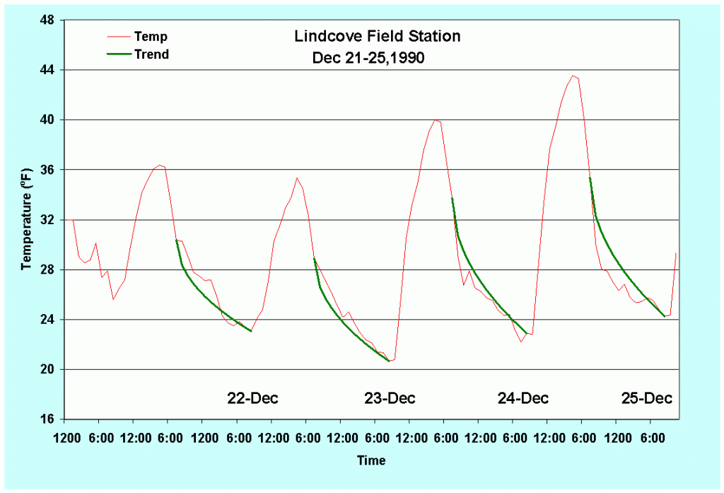
Figure 3. Predicted and observed temperature (oF) traces for December 21-25, 1990.
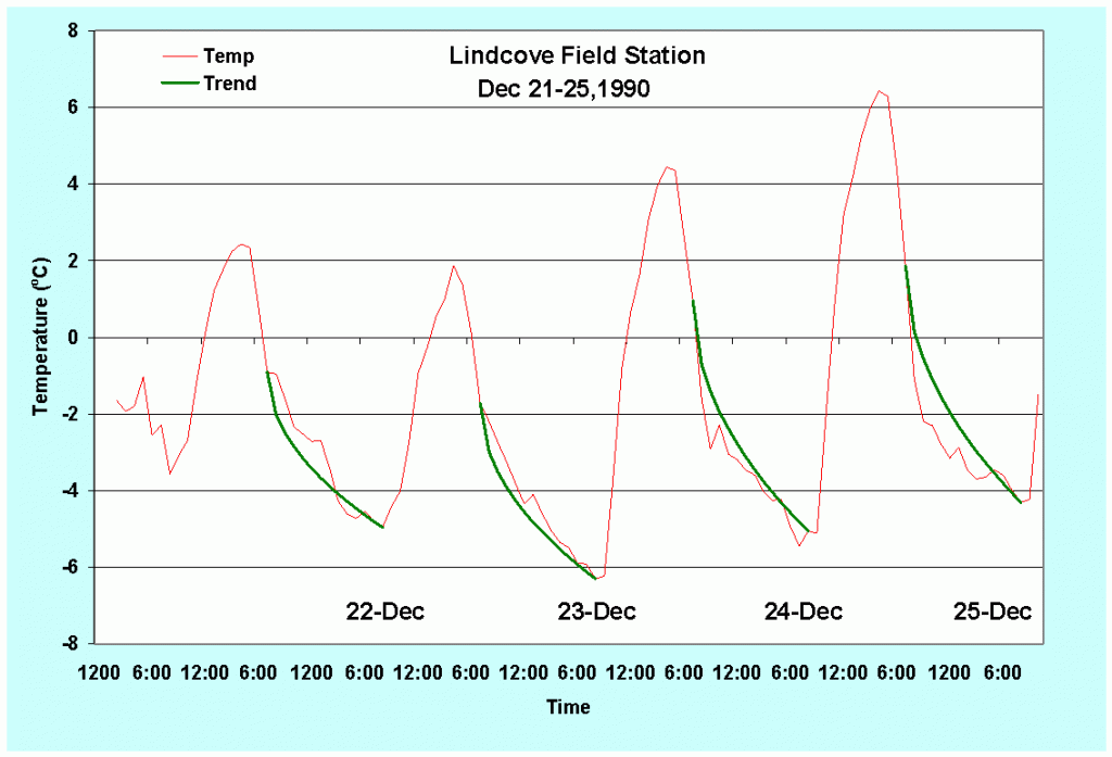
Figure 4. Predicted and observed temperature (oC) traces for December 21-25, 1990.
When using wind machines for freeze protection, the fans should be started while the temperature measured at about 5 ft (1.5 m) height is above the critical damage temperature and before the 5-ft (1.5 m) height temperature falls much below the 33-ft (10 m) height temperature. There is some evidence that under very strong inversion (temperature increasing rapidly with height) conditions, air near the surface becomes stratified and stable. This may lead to problems mixing the air. Therefore, it is best to start when the inversion is not too strong. If the inversion is weak and damage is expected when the crop is exposed to a critical temperature Tc=30oF (-1.1oC) for half-an-hour, then the fans should be started one hour prior to when the mean air temperature during the preceding hour equals 30oF (-1.1oC). Moving the start time ahead by one hour generally insures that the fans will be started before damage is likely. Using Figures 1 and 2, the mean hourly temperature was about 30oF (-1.1oC) at 8:30 p.m. Therefore, the fans should be started at about 7:30 p.m.
When using sprinklers for freeze protection, the sprinklers should be started and stopped when the wet-bulb temperature (Tw) is above the critical damage temperature (Tc). This is discussed in Quick Answer – FP001. The air temperature to start the sprinklers is estimated by first measuring the dew point (Td) temperature (see Quick Answer – FP003). Then use Table 1 or 2 to determine the starting temperature by finding Tw=Tc in the top row and Td in the left-hand column of the table. The sprinklers should be started when the observed temperature is at or above the corresponding air temperature (T) listed in the table. If Td=23oF (-5.0oC) and Tc=30oF (-1.1oC), then the sprinklers should be started when the air temperature is at or above 34.0oF (1.1oC). This is because Tw=30oF (-1.1oC) when Td=23oF (-5.0oC) and T=34.0oF (1.1oC). Using Figures 1 and 2, the mean hourly temperature was about 34oF (1.1oC) for the hour ending at 7:00 p.m. Therefore, the sprinklers should be started about one hour earlier at 6:00 p.m.
Table 1. Minimum turn-on and turn-off air temperatures (oF) for sprinkler frost protection for a range of wet-bulb and dew-point temperatures (oF)*
| Dew-point Temperature | Wet-bulb Temperature (oF) | |||||||||||
| oF | 22.0 | 23.0 | 24.0 | 25.0 | 26.0 | 27.0 | 28.0 | 29.0 | 30.0 | 31.0 | 32.0 | |
| 32 | 32.0 | |||||||||||
| 31 | 31.0 | 32.7 | ||||||||||
| 30 | 30.0 | 31.7 | 33.3 | |||||||||
| 29 | 29.0 | 30.6 | 32.3 | 34.0 | ||||||||
| 28 | 28.0 | 29.6 | 31.2 | 32.9 | 34.6 | |||||||
| 27 | 27.0 | 28.6 | 30.2 | 31.8 | 33.5 | 35.2 | ||||||
| 26 | 26.0 | 27.6 | 29.2 | 30.8 | 32.4 | 34.0 | 35.7 | |||||
| 25 | 25.0 | 26.5 | 28.1 | 29.7 | 31.3 | 32.9 | 34.6 | 36.3 | ||||
| 24 | 24.0 | 25.5 | 27.1 | 28.6 | 30.2 | 31.8 | 33.5 | 35.1 | 36.8 | |||
| 23 | 23.0 | 24.5 | 26.0 | 27.6 | 29.1 | 30.7 | 32.3 | 34.0 | 35.6 | 37.3 | ||
| 22 | 22.0 | 23.5 | 25.0 | 26.5 | 28.1 | 29.6 | 31.2 | 32.8 | 34.5 | 36.1 | 37.8 | |
| 21 | 22.5 | 24.0 | 25.5 | 27.0 | 28.5 | 30.1 | 31.7 | 33.3 | 34.9 | 36.6 | 38.2 | |
| 20 | 22.9 | 24.4 | 25.9 | 27.4 | 29.0 | 30.6 | 32.1 | 33.7 | 35.4 | 37.0 | 38.7 | |
| 19 | 23.4 | 24.9 | 26.4 | 27.9 | 29.4 | 31.0 | 32.6 | 34.2 | 35.8 | 37.5 | 39.1 | |
| 18 | 23.8 | 25.3 | 26.8 | 28.3 | 29.8 | 31.4 | 33.0 | 34.6 | 36.2 | 37.9 | 39.5 | |
| 17 | 24.2 | 25.7 | 27.2 | 28.7 | 30.2 | 31.8 | 33.4 | 35.0 | 36.6 | 38.3 | 39.9 | |
| 16 | 24.6 | 26.1 | 27.6 | 29.1 | 30.6 | 32.2 | 33.8 | 35.4 | 37.0 | 38.7 | 40.3 | |
| 15 | 25.0 | 26.4 | 27.9 | 29.5 | 31.0 | 32.6 | 34.2 | 35.8 | 37.4 | 39.0 | 40.7 | |
*Select a wet-bulb temperature and dew point temperature and read the corresponding air temperature from the table. This table assumes a barometric pressure of 1013 millibars (101.3 kPa).
Table 2. Minimum turn-on and turn-off air temperatures (oC) for sprinkler frost protection for a range of wet-bulb and dew-point temperatures (oC)*
| Dew-point Temperature | Wet-bulb Temperature (oC) | |||||
| oC | -5.0 | -4.0 | -3.0 | -2.0 | -1.0 | 0.0 |
| 0.0 | 0.0 | |||||
| -1.0 | -1.0 | 0.7 | ||||
| -2.0 | -2.0 | -0.4 | 1.3 | |||
| -3.0 | -3.0 | -1.4 | 0.2 | 1.9 | ||
| -4.0 | -4.0 | -2.5 | -0.9 | 0.8 | 2.4 | |
| -5.0 | -5.0 | -3.5 | -1.9 | -0.4 | 1.3 | 2.9 |
| -6.0 | -4.5 | -3.0 | -1.5 | 0.1 | 1.8 | 3.4 |
| -7.0 | -4.1 | -2.6 | -1.0 | 0.6 | 2.2 | 3.9 |
| -8.0 | -3.6 | -2.1 | -0.6 | 1.0 | 2.6 | 4.3 |
| -9.0 | -3.3 | -1.7 | -0.2 | 1.4 | 3.0 | 4.7 |
*Select a wet-bulb temperature and dew point temperature and read the corresponding air temperature from the table. This table assumes a barometric pressure of 1013 millibars (101.3 kPa).
Last updated on October 21, 2003